Interpretation
LIME has in-built interpretation and digitisation tools for measuring distances and orientations, creating lines and planes and placing points of interest. Combined with Panels, these are the building blocks of a marked-up virtual environment or field trip in LIME.
Lines
Lines are easily created and edited by digitising points on a 3D model. Organise your lines with colour, names and folders to structure your project (have you tried to revisit an old interpretation you have made, or a project you have received from someone else, where organisation and naming is not obvious?!). Lines can be closed to create polygons, and it is possible to snap to other 3D elements to share vertices, edges and topology.
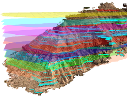
Outcrop model from the Book Cliffs, Utah, showing interpretation lines and digital surfaces representing key stratigraphic layers.
Orientation planes
Orientation measurements can be made directly on a loaded 3D model. Choose to create simple 3-point planes or best-fit planes using lines. Planes can be displayed as ellipses or rectangles, and coloured according to orientation (dip, dip direction and strike in structural geology, slope/aspect in GIS terminology😃). Transparency is changed using the display settings of the planes. The plane data can be exported to a simple ASCII file for analysis in external spreadsheet or stereonet software.
Orientation measurements made on outcrops around Arches road cut, Utah, USA (Arches Road Cut, VOG Group, https://v3geo.com/model/98).
Points
Points can be added to denote areas of interest, sampling or measurement points, origin of specimens, or simply labelling features in the 3D scene. In addition, Points can be combined with icons to indicate supplementary information or data available at a particular location in the 3D scene. Add file links to Points to display images, videos and PDF files.
Mark-up of the Ainsa Quarry, northern Spain, showing some of the uses of Points (Ainsa Quarry (2013), VOG Group, https://v3geo.com/model/30).
